Methods of developing buffer plans vary widely depending on program requirements, complexity of the project, and staff preferences. For any buffer project, review project goals, site analysis information, and design considerations to make sure that the project will consider as many variables as possible. Also, develop a concept plan. Simple projects may not need intricate plans that show the exact boundaries of plantings and planting zones, but detailed plans play an important role in guiding projects that include multiple conservation practices, seeding zones, and types of vegetation.
| Review Goals |
The first step in plan development involves reviewing project goals that were set after the project was selected. This initial planning will influence final decisions about practices that will be selected to solve resource issues and maximize ecological benefits. |
| Review Site Analysis Information |
The information that was collected during the site analysis portion of the project also plays a key role in plan development. Project soils and geology, landuse, topography, hydrology, native plants and plant communities, invasive species, and important natural resources will all figure into the design process. |
| Review Design Considerations |
Part Five of the toolbox summarizes design considerations for buffer projects. These design considerations are summarized in the table to the right. These should be fully considered and reviewed as part of the plan development process. Design Considerations: Systems Approach, Designing for multiple functions, Balancing multiple uses, Creating corridors and connections, Protecting resources, Providing habitat for specific wildlife, Planning diversity levels, Planning buffer width, Buffer zones, Technical Assistance |
Selecting Conservation Practices
Buffer projects involve vegetation planning or management in riparian areas but they may also involve practices in agricultural fields, such as grass waterways or contour buffer strips, to control pollutants. Some practices such as side inlets along ditches or contour buffer strips in fields may also be combined with plantings along agricultural ditches. For many agency-funded (including BWSR) buffer projects, NRCS practice standards and accompanying job sheets are used for planning guidance. Practice Standard 327, “Conservation Cover” is commonly used for planning buffer vegetation. It provides flexibility for diversity levels and meeting a variety of project goals including bird nesting and pollinator habitat. Practice Standard 643, “Restoration and Management of Declining Habitats” may be used for larger fields such as Reinvest in Minnesota easements. Practice 393, “Filter Strips” provides guidance for planning buffer width and may be used separately to address areas of sediment loss; the table in the practice standard can be used to help plan variable buffer widths based on slopes and soil types. Other practice standards are available for planning practices such as grass waterways, contour buffer strips, and side inlets.
NRCS Practice Standard for Buffer Establishment
| Practice Standard |
Purposes: Note: One or multiple purposes may be met for each practice |
|---|---|
| 327- Conservation Cover |
|
| 332- Contour Buffer Strips |
|
| 340- Cover Crops |
|
| 386- Field Border |
|
| 393- Filter Strip |
|
| 412- Grassed Waterway |
|
| 694- Restoration and Management of Declining Habitats |
|
| 391- Riparian Forest Buffer |
|
Developing Concept and Final Plans
Concept plans are used to refine buffer planning and show landscape elements such as the project boundary, trees and shrubs, locations of planned seed mixes or other plant materials, locations of invasive species to be controlled, and areas of native vegetation to be kept intact.
Once a concept design has been approved by project partners, a detailed plan can be created. Detailed plans show exact locations of seed mixes to be installed, as well as other plant materials. They provide detailed written direction for all phases of the project, including site preparation, installation, and maintenance. A detailed schedule, often included, shows how all phases of a project will work together.
A Shoreland Habitat Restoration Technical Note (pdf) has been developed to aid the development of project plans for shoreland projects.
|

|
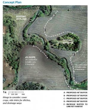
| This concept shows one swale and one slope coming into a public waters river. Using the table from the NRCS “Filter Strip” practice standard (to treat sediment and phosphorus) and information collected during site assessment, the swale would need an 80- foot buffer and the slope would need a 60-foot buffer. Other areas would have an average 50-foot buffer from the edge of bank to meet the Minnesota Buffer Law. The concept shows areas where the buffer could be considered to link the existing wetland to conservation lands to the north to benefit wildlife. Other BMPs that should be considered include a grass waterway for the swale and a side inlet for the drainage ditch. | The final buffer plan shows the location of the buffer, the widths and seed mixes to be used for different portions of the sites. The seed mixes could be shown on the final plan but are often included in an accompanying document. |