Once you have a watershed plan and clear goals, it is time to select specific sites. This is where the concept of Prioritize-Target-Measure again factors into the planning process. There may be several solutions to a given problem and, likely, more sites than funding to cover them. Project selection involves a combination of using tools to determine where goals can best be accomplished and developing relationships with potential landowners. In recent years, there has been more use of mapping, GIS, and terrain analysis tools to aid project selection. This type of approach requires in-depth knowledge of the landscape (a strength of local staff) and uses data such as topography, soil types, land use, impaired waters, intact plant communities, etc. This information assists decision-making about what projects will attain the greatest environmental benefits.
The following topics focus on site selection considerations based on project goals. Specific information is presented for water quality and wildlife habitat projects. There are many other potential project goals and each will influence the project selection process.
Project Selection for Water Quality
Watershed conditions are a major consideration when selecting projects for water quality benefits. Hydrologic conditions and surrounding land use have a big influence on the long-term success of a buffer project. Remember that even developed areas can incorporate low-impact design that includes open space for natural water control and retention. Even if paved with traditional impervious surfacing, narrower roads with runoff swales and landscaped filter strips can contribute to improved water quality. Zoning and building codes can be used to preserve high-value infiltration areas—if they are identified ahead of time.
Multiple BMPs may be needed to ensure that a buffer will function effectively in disturbed landscapes. Specific conditions within a watershed can also influence buffer effectiveness and the need for buffers. The following are examples of high priority areas for water quality buffers:
| Areas with high pollutant loads | Agricultural fields that become saturated during storms and then carry pollutants to water bodies should be priority areas for buffers. Storm water can carry a significant amount of sediment and nutrients; additional BMPs may be needed to protect the buffer, or soil stabilization practices should be applied. |
|
| Groundwater Recharge Areas | These areas require protection to filter nutrients and pollutants. In an area of groundwater recharge, buffering connections to surface water discharge may provide wildlife habitat while protecting groundwater, and possibly drinking water. |
|
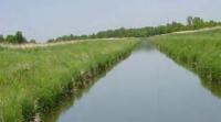
| Ephemeral Channels and Low-Order Streams | Often in upper reaches of a watershed, these waterways can significantly improve downstream water quality when buffers are established. In particular, they are areas of high nitrogen removal (Perry et al. 1999). Placing riparian buffers along small or low-order streams multiplies the effect of the buffer all the way down the waterway; like compounding interest on a retirement account, even a small initial investment accrues enormous long-term benefits over time. |
|
| Agricultural Fields with steep slopes or fine soils | These lands are prone to erosion; buffers stabilize soils and filter runoff during storms. |
|
Specific modeling tools are available for the planning of buffers and other BMPs through assessing potential pollutant loading and mitigation. Many new tools are GIS-based and incorporate land use, soils, topography, and hydrology information. Tools being used include: HSPF, SWAT, HSPF-SAMS, PTM App, ACPF, MnTOPO, etc.
To define the specific benefits (potential outcomes) of a project, BWSR has developed calculators for soil loss and water quality benefits. These calculators provide a method for project planners to measure potential outcomes and determine cost effectiveness of a project.
Project Selection for Wildlife
When selecting projects for wildlife, it is important to define the specific species that will be targeted. The Minnesota Wildlife Action Plan outlines a set of species in greatest need and creates a conservation approach that seeks to ensure their survival in the State. The Minnesota Department of Natural Resources also has a list of Minnesota species of greatest conservation need.
Information about the habitat requirements of individual species is also useful. Fact sheets about habitat needs for specific wildlife species are available from the Natural Resource Conservation Service website. Specific information about habitat needs of ground nesting birds can also be found on a United States Geological Survey Website.
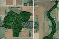
When selecting sites for wildlife habitat, have a basic understanding of landscape ecology. The concepts are general in nature but apply to a wide variety of bird and animal species. Habitat fragmentation, remnant habitat patches, corridors, and edge effect should influence your selection of buffer locations and, later, project assessment and design. The following descriptions of these topics include considerations for each to aid site selection.
| Habitat Fragmentation |
The breaking up of previously continuous habitat into separate, smaller segments. Most fragmentation results from human land use, such as forestry, agriculture, and development, but in some cases it can be caused by natural disturbance such as wildfires. In Minnesota, development with housing, roads, fences, and other structures breaks up continuous areas of forests, grasslands, and wetlands. Fragmented landscapes have led to significant species loss in the Midwest. Fragmented landscapes are more prone to invasive species. Considerations: Buffers can decrease fragmentation by extending the size of natural plant communities and creating connections between isolated habitats. |
|
| Remnant habitat patches |
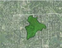
Forests, prairies, and wetlands that have not been significantly degraded by human activity. Many remnant populations have been isolated by fragmentation and are at risk from invasive species, predation, and genetic isolation. Very small habitat patches surrounded by development or agriculture can become a habitat “sink” due to predation, leading to a net loss of wildlife such as birds that use an area for nesting. Considerations: Buffers can be used to expand the size of remnant communities and connect them to corridors and other remnants. Remnant plant communities can act as seed sources for buffer plantings. Because of the many environmental benefits to buffering and creating connectivity among them, remnant habitat patches are priority areas for buffer projects. |
|
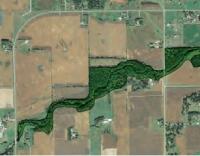
| Corridor |
Common along waterways in Minnesota, corridors are strips of habitat that differ from the adjacent land (often degraded) on both sides. Corridors provide connections between remnant habitat patches that would otherwise be isolated. Declines in plant and animal diversity are often due to a lack of re-colonization from other landscape fragments; corridors can help promote re-colonization. Considerations: Corridors play an important role in connecting remnant habitat patches and decreasing their isolation. They can act as pathways for animals and for the distribution of plants. When wildlife is a primary goal, projects that incorporate one or multiple corridors between natural areas may rank higher than other projects. Even a narrow corridor will allow species to migrate as climate, seasonal, and landscape changes affect their refuge habitat. This benefits mostly highly-mobile, adaptable species (that may include invasives) that can move between sensitive areas. Locating corridors and patches along a range of elevations, soils, and spatial scales may protect biodiversity by meeting different plant and animal requirements. Even a “stepping stone” strategy may provide an opportunity for dispersal during |
|
| Edge effect |
Negative influences from predators, herbicide drift, invasive species, and other factors that can degrade the integrity of an isolated plant community. Considerations: Edge effect is minimized by having large core areas and by creating wide corridors. Buffers can be used to expand core areas of habitat patches and existing corridors to decrease edge effect. Projects may be selected in areas where buffers will significantly increase core areas of remnant habitat patches. |
|