(with 50’ avg. buffer standard)
Purpose and Considerations
This common alternative practice may be applicable in locations where:
- the land slope is away from the top of the bank of a water body, or there are existing high areas next to the bank which prevent flow from uniformly entering the water body;
- runoff typically enters the water body through open channel concentrated flows;
- runoff typically enters the water body through an installed pipe or conduit;
Note: Alternative practices installed per this document within shoreland zoning districts should be coordinated with county or municipal officials responsible for shoreland ordinance provisions.
Implementation Guidance
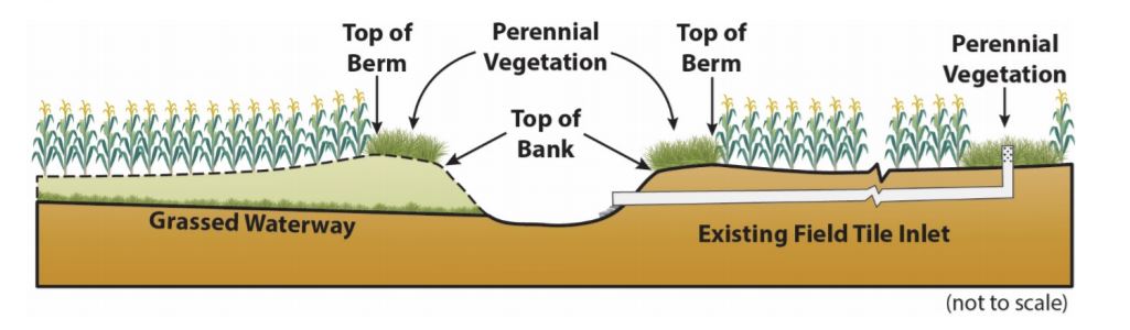
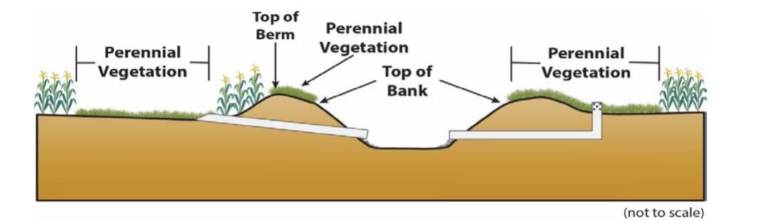
- SWCD should verify that undisturbed perennial vegetation is installed from the top of the bank to the top of the constructed or natural berm, if one exists, but not less than 16.5 ft landward from the top of the bank. This perennial vegetation helps provide bank stability, serves as a tillage setback to prevent sedimentation and direct application of fertilizer or pesticides below the waterbody.
- In addition to the perennial vegetation, treatment of all discharge which flows into the waterbody via concentrated flow or other conduit may be treated using a combination of situations 1-3 below.
- Site-specific diagrams or pictures should be used to document validations.
Situation #1: Runoff approaches as concentrated flow and discharges via a conduit, structure or vegetated pathway that meets NRCS Design standards.
- SWCD staff should confirm that outfall locations are stable and functioning as intended to prevent erosion, reduce flow or trap sediment.
- SWCD staff should determine that the practice or structure(s) will be/is functioning as intended to provide the as-designed water quality functions.
Situation #2: Runoff approaches as concentrated flow and discharges via a conduit or structure or vegetated pathway that does not meet NRCS Design standards.
- SWCD staff should confirm that outfall locations are stable and functioning as intended to prevent erosion, reduce flow or trap sediment.
- Develop a drainage area map(s) for all outfall locations to determine depth/length of a critical area planting where all areas of concentrated flow enter through a structure or channel which is not based on a NRCS design standard. For consistency and predictability purposes, some suggested dimensions have been provided in the table below for low slope sites. When using the table, SWCD staff should consider site specific factors such as topography, soil types and tillage management to assure comparable water quality benefit.
| Area Draining to Site (Acres) | Width (Ft.) Perennial Veg. | Length (Ft.) Perennial Veg. |
| <50 | 10-20 | 25-50 |
| 50-200 | 15-25 | 30-60 |
| >200 | 20-30 | 60-120 |
- Use NRCS Code 342 (pdf) (Critical Area Planting) or 327 (pdf) (Conservation Cover) specifications to determine proper seed mixture. Seed tags and invoices to show that site was seeded to Critical Area Planting or Conservation Cover specifications may be needed for SWCD validation.
Situation #3: Water flows overland to open tile intake(s).
- Establish perennial vegetation around all open tile intakes within the parcel adjacent to the waterbody, following the NRCS 393 (pdf) practice standard. (Typically 15’-60’ radius.)
Notes:
- In any areas where perennial vegetation is established to treat runoff occasional maintenance and reshaping and re-seeding to maintain flow and remove and distribute vegetative mass may be useful. Side inlets or similar structural practices will also require occasional maintenance to function as designed.
- A DNR public waters work permit may be required for course, current or cross-section alterations below the Ordinary High Water Level of a Public Water. Landowners should contact their DNR Area Hydrologist (pdf) before starting a project to determine if permitting requirements may apply.
Comparable Benefits
This common alternative practice provides treatment of runoff along the entire frontage of the waterbody. In instances where all land flows away from the top edge of the constructed channel, it provides a tillage setback. The perennial vegetation helps provide bank stability and serves as a tillage setback to prevent direct application of fertilizer or pesticides below the top of bank or normal water level. It also helps prevent direct disturbance of the banks so soil is not deposited directly onto the banks or into the water body due to tillage practices. The concentrated inflow measures provide for stable outfalls and retention areas where establishing fifty feet of perennial vegetation would provide minimal treatment or prevention of sediment and sediment associated constituents. Use of the combination of perennial vegetation and discharge structures or other vegetated areas will provide comparable or greater water quality benefit.
Illustrations