(50' Avg. Buffer Standard)
Purpose and Considerations
This common alternative practice may be applicable in locations where a watercourse identified on the Buffer Protection Map has:
- no clearly defined bed or bank; and
- no normal water level; and
- a resource concern has been identified.
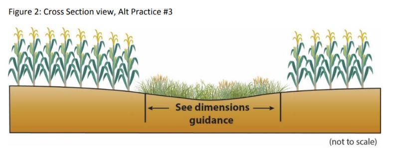
For the purposes of this common alternative practice, the definition of a grassed waterway is: “A shaped or graded channel that is established with suitable vegetation to convey surface water at a non-erosive velocity using a broad and shallow cross section to a stable outlet”. The purposes of grassed waterways are to convey runoff from locations where runoff is concentrated, including terraces, diversions, or other concentrated flow, without causing erosion or flooding, to reduce gully erosion and to protect/improve water quality. This practice is applied in areas where added water conveyance capacity and vegetative protection are needed to prevent erosion and improve runoff water quality resulting from concentrated surface flow.
Note: Alternative practices installed per this document within shoreland zoning districts should be coordinated with county or municipal officials responsible for shoreland ordinance provisions.
Implementation and Dimensions Guidance
Situation #1: Where a watercourse is functioning similar to a grassed waterway SWCD staff should validate the following;
- The watercourse has intermittent/temporary flow; and
- There are no signs of ephemeral erosion in the waterway or adjacent field; and
- The waterway is adequately vegetated.
Note: SWCDs can propose additional measures to address identified resource concerns.
Situation #2: Where a watercourse is cultivated and there is not a grassed waterway present, SWCD staff may consider the following options if they have determined there is a resource concern to be addressed;
- Option #1: A flat bottom with 10:1 side slopes and vegetation establishment following the NRCS Critical Area Planting standard 342 (pdf), or Conservation Cover standard 327.
- Option #2: Designed and built according to the NRCS Grassed Waterway standard 412 (pdf).
Notes:
- Occasional mowing and harvest of vegetation is encouraged, if funding sources allow such maintenance, so that accumulated nutrients can be removed.
- A DNR public waters work permit may be required for course, current or cross-section alterations below the Ordinary High Water Level of a Public Water. Landowners should contact the DNR Area Hydrologist (pdf) before starting a project to determine if permitting requirements may apply.
- Design considerations: when a perforated tile line(s) is required to stabilize the waterway and meet NRCS specifications, the tile should meet the following conditions, unless SWCD or NRCS staff otherwise confirm it is the minimum necessary to support a stable grassed waterway and outlet:
- The tile is not larger than 4” in diameter; and
- A single tile line is used without additional lateral tile lines connecting into it; and
- Conservation style tile intakes are used if any surface intakes are required to support the waterway; and
- The tile outlet does not create additional erosion.
Comparable Benefits
This procedure provides some treatment for overland flow entering the grassed waterway along the general location of the public watercourse with the grassed bottom and side slopes of the waterway. Further, it provides a stable flow path preventing gully formation in areas where intermittent concentrated flow and row crop agricultural production could otherwise lead to significant erosion. This stabilization also will provide protection which would not have been provided if a gully were allowed to re-form and continually move. Considering all of the above information, a stable grassed waterway implemented as listed in the information above will provide protection from erosion and sedimentation and additional comparable water quality benefits.
Illustration