Introduction
Water planning within Minnesota and nationwide has been evolving to emphasize integrated water resources management at a watershed scale to solve soil and water resource issues. Issues related to water planning are wide-ranging and vary between watersheds, including urban stormwater management, agricultural water quality, subsurface sewage treatment, land use practices, plant community management, construction practices and climate change impacts.
Many types of water planning have been conducted in Minnesota at different levels of government, including watershed district management plans and watershed management organization plans, counties, and other local and regional partners.
Planning Methods and Programs
One Watershed, One Plan
One Watershed, One Plan (1W1P) is a BWSR program that supports partnerships of local governments in developing prioritized, targeted, and measurable implementation plans. Key principles are planning at the major watershed scale and aligning local plans with state strategies. Plans created through the 1W1P program are called comprehensive watershed management plans and are described in §103B.801.
County Comprehensive Local Water Management Planning:
Counties with their planning and land-use authorities, are uniquely positioned to link many land-use decisions with local goals for surface and groundwater protection and management. Through the Comprehensive Local Water Management Act, counties are encouraged to make this link through the development and implementation of comprehensive local water management plans (county water plans). BWSR's role in local planning is to ensure that county water plans are prepared and coordinated with existing local, and state efforts; and that plans are implemented effectively. BWSR fulfills this role through Board review and approval of the plans while BWSR staff provide overall program guidance, process related grants, and provide plan review and comments. All parts of Minnesota have state-approved and locally-adopted county water plans in place. However, water management in Minnesota has been evolving towards watershed-based, rather than jurisdictionally-based water plans (i.e., One Watershed, One Plan (pdf)).

The Nonpoint Priority Funding Plan (NPFP):
In 2013, the Minnesota Legislature passed a law requiring the Board of Water and Soil Resources (BWSR) to prepare and post on its website a Nonpoint Priority Funding Plan (pdf) to prioritize potential nonpoint restoration and protection actions based on available Watershed Restoration and Protection Strategies (WRAPS), Total Maximum Daily Load (TMDL) plans and local water plans. The Nonpoint Priority Funding Plan is a criteria-based, systematic process to prioritize Clean Water Fund (CWF) nonpoint implementation investments.
Minimal Impact Design Standards (MIDS):
State agencies are focusing on using low impact design, and volume control best management practices (BMPs) to address issues related to large storm events. Impervious surfaces are increasing faster than population growth. This increase in impervious surface coupled with larger storm events will have a significant impact on receiving waters. Minimal Impact Design Standards (MIDS) are being used to increase infiltration and reduce runoff (including green infrastructure like rain gardens, urban forestry/trees, pervious pavement, swales, etc.). These practices are now focusing on volume control in addition to pollutant and rate control. Volume control, and working to mimic natural hydrology helps to result in less dramatic runoff events, which reduces stream erosion and scouring.
Minnesota Hydrogeology Atlas:
The Minnesota Department of Natural Resources (MN DNR), Ecological and Water Resources Division’s Minnesota Hydrogeology Atlas (MHA) is a series of statewide, county, and regional maps and reports that can be used by government agencies in planning efforts to protect and preserve groundwater, to provide information for water appropriations permitting, for source water protection and well sealing programs, and for emergency response to contaminant releases. The MHA expands, compiles, and updates data developed by the County Geologic Atlas Program (CGA) providing more accessibility to information such as regional water pollution sensitivity to bedrock surface and near-surface materials, depth to water table, and water table elevation. The MHA includes a user’s guide, and lists training contacts and funding sources. Numerous links present users with a variety of state and national resources to assist in planning efforts including the DNR’s Watershed Health Assessment Framework, the USDA Web Soil Survey, and the Minnesota Geospatial Commons.
Minnesota State Hazard Mitigation Plan:
The State Hazard Mitigation Plan, updated in 2019 by the Minnesota Division of Public Safety Department of Homeland Security and Emergency Management (HSEM), provides unified guidance to reduce and/or prevent injury and ensure coordination of recovery-related hazard mitigation efforts following major hazard events. The State’s 20 major hazards are identified, including flooding, drought, and ground and surface water supply contamination as they relate to geographic and demographic characteristics, development trends, and climate change. Local governments can use the county by county assessment of mitigation goals, strategies, actions, and initiatives to develop and update their plans. The plan provides information and resources on ranking and criteria for hazard identification, and determining steps to declare an emergency. Resources include a listing of agencies and organizations that may assist with mitigation efforts, and an inventory and brief descriptions of funding programs including the Hazard Mitigation Grant Program. Hazard mitigation success stories are also listed.
Key Strategies
1) Sustainable Regional and Urban Planning. Urban and regional planning that considers protection of natural areas, development of green infrastructure, and minimization of impervious areas during development and re-development can help to treat both water quality and quantity though a variety of practices.
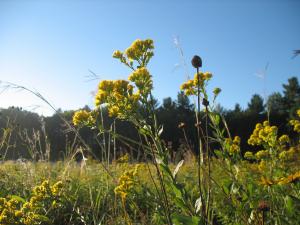
2) Protecting and Restoring Natural Areas. Protecting and restoring diverse natural habitats provides multiple benefits including water quality protection for groundwater and surface water, stable plant composition to resist invasive species, protect pollinator populations, preserved and improved wildlife habitat, and resiliency to weather extremes. For water planning it is recommended to identify high priority natural habitats including wildlife and water quality complexes and corridors, and promote a combination of agricultural BMPs, buffer programs, conservation plantings, wetland projects and riparian activities that will protect, restore and link water quality and habitat corridors. Minnesota’s Wildlife Action Plan and Prairie Conservation Plan are resources that can be used to aid planning efforts.
3) Riparian Management. Protecting and restoring riparian areas, including adjacent floodplains brings multiple benefits by reducing soil erosion, increasing stream channel stability, decreasing phosphorus and nitrogen loading, flood attenuation, improving wildlife habitat and wetland functions. Water plans should identify high priority areas for riparian buffer easements, riparian erosion and sediment reduction, wetland restoration and other water storage and nutrient treatment opportunities, and target implementation efforts in those areas.
4) Treating Water Close to Where it Falls. Higher amounts of rainfall from storm events in recent years increases the need to capture precipitation as close to where it falls as possible; prior to flowing into streams, lakes, and rivers and contributing to erosion and flooding. Stormwater runoff also transports high concentrations of pollutants into water bodies, causing impairment. To reduce these impacts, best management practice methods like cover crops, detention basins, vegetated swales, catch basins, infiltration basins, infiltration trenches, bioretention cells, grass swales, buffer strips, green roofs, etc. can improve water quality.
5) Using Water Treatment Trains in Agricultural Landscapes. In agricultural landscapes it is beneficial to implement combinations of best management practices that promote soil health and the ability of soils to capture and store rainfall, and store carbon. Examples of key practices for agricultural areas include perennial crops, conservation tillage, conservation drainage, cover crops, buffer strips, and wetland restoration to manage water resources. These practices reduce runoff, recharge groundwater, maintain agricultural productivity, improve water quality, and 9educe flooding.
6) Using Stormwater Treatment Trains in Urban Landscapes. In urban areas it is beneficial to implement combinations of practices to slow water volume and improve water quality. Practices in urban areas that are commonly combined include raingardens, infiltration trenches, treatment swales and detention basins.
7) Strategic Site Selection. Water quality practices should be located where they will have the greatest landscape benefits to maximize the value of conservation funding. The Nonpoint Priority Funding Plan (pdf) (NPFP) helps to prioritize potential nonpoint restoration and protection actions based on available Watershed Restoration and Protection Strategies (WRAPS), Total Maximum Daily Load (TMDL) plans and local water plans.
8) Nutrient Management. Detailed Nutrient Management Plans play a key role as an operational practice along with conservation practices in protecting water bodies from nutrients in agricultural areas.
9) Wetland Protection and Restoration. Wetland protection and restoration provides benefits for water quality, peak flow reduction, habitat and wildlife. Water plans should support the continued implementation of the Wetland Conservation Act and look for opportunities to improve coordination across jurisdictional boundaries. The plan should also identify high priority areas for wetland restoration and strategically target restoration projects to those areas. The Restorable Wetlands Prioritization Tool is one resource that can be used to help identify areas for wetland restoration.
10) Protecting Groundwater. It is important to identify priority areas for drinking water/groundwater planning, and management such as source water protection areas, groundwater management areas, and areas of groundwater/surface water interaction; or concerns about groundwater overuse or contamination that need to be addressed in plans. Ineffective septic systems and subsurface treatment practices are also important considerations.
11) Sustainable Forest Management. Protecting the health of forests by sustainable forestry practices and control of invasive species can maintain the health of forest soils and plant communities that promote the infiltration and filtering of water before it reaches streams, rivers, lakes and wetlands. Long-range forest management plans are an important tool for maintaining healthy forests.
12) Minimizing Landscape Stressors. Investigate opportunities to improve environmental conditions throughout watersheds to decrease environmental stressors such as flooding, water level fluctuations, sedimentation, environmental pollutants, decreasing water tables, or invasive species that can significantly detract from key ecological functions into the future.
13) Increasing Perennial Vegetation. Areas of plant diversity supports wildlife species and increases resiliency by helping plant communities function as intact ecological systems during climate variation. Planting native species also prevents the establishment of invasive species. Diverse state seed mixes are available for a variety of project types and the Minnesota Wetland Restoration Guide summarizes restoration strategies for uplands and wetlands. The MPCA publication Plants for Stormwater Design summarizes environmental tolerances of native vegetation.
14) Preserving and Restoring Soil Health. The use of cover crops and perennial vegetation is recommended to promote good soil structure, organic content and microorganism populations that promote healthy soils and sustain productive ecological and agricultural landscapes. Maintaining more vegetation more of the time increases evapotranspiration during the spring and fall seasons, reduces runoff and erosion and helps recycle nutrients. Root systems increase organic matter in the soil profile, which increases infiltration and water holding capacity for plant available water, and also reduces runoff, erosion and nutrient transport.
15) Adapting to Climate Change. A major climate trend in Minnesota has been an increase in intense rainfall events that stress aquatic systems, cause erosion, and transport sediment and nutrients. Partners that are working on water plans should consider the potential for more extreme weather events and the implication for water and land resources. BWSR’s Climate Change Trends and Action Plan (pdf) provides details about climate change adaptation for conservation and protection of natural resources. All of the strategies summarized in this Toolbox play a role in climate adaptation efforts. In addition to the strategies already summarized related to water planning it is also important that NOAA Atlas 14 rainfall frequency data and good BMP/landscape planning and design practices are used to address larger storm events. It is also important to identify landscape and populations at risk from climate change trends.
16) Public Engagement. Finding ways to engage landowners in projects within urban or rural communities can be an important way to promote conservation efforts. This can be accomplished though volunteer events, tours or promoting community gatherings where projects are featured. Having landowners speak about the benefits of projects on their property can be an effective method of convincing other landowners to sponsor projects.
17) Practicing Adaptive Management. Adjust management practices based on monitoring efforts and experience with successes and failures to improve the long-term effectiveness of management practices and resiliency of plant communities. Practices such as prescribed burning, water level management and prescribed grazing and haying may replicate natural disturbances and promote diversity and resiliency. BWSR’s What’s Working webpages summarize strategies that have been successful for conservation professionals.
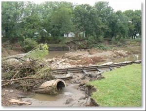
18) Disaster Response. Flooding has caused significant damage to private lands and conservation practice infrastructure in Minnesota. Since 2000, BWSR has distributed $53 million in southeast, northeast and northwest Minnesota under the Disaster Recovery Assistance program to install, repair, or rehabilitate erosion and sediment control and water quality and watershed protection projects damaged by flooding. The Division of Homeland Security and Emergency Management (HSEM) also helps Minnesotans prevent, prepare for, respond to and recover from disasters among its other responsibilities. This includes efforts to reduce the risk to people and property from natural and human-caused hazards by developing and implementing long-term mitigation measures that will reduce or eliminate the severe effects of future disasters.